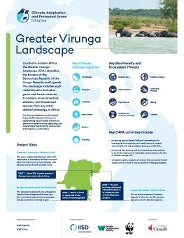
The Greater Virunga Landscape
In the Greater Virunga Landscape (GVL), the Climate Adaptation and Protected Areas (CAPA) Initiative will focus on nature-positive livelihood interventions and the restoration of degraded lands in and around protected areas. Working with local civil society and community members, CAPA Initiative activities will be carried out in southwest Uganda.
Located in Eastern Africa, the GVL straddles the borders of the Democratic Republic of the Congo, Rwanda, and Uganda. The landscape includes eight national parks and other game and forest reserves. It contains more terrestrial, endemic, and threatened species than any other defined landscape in Africa. However, the region is experiencing several climate change impacts, including landslides, erosion, flooding, droughts, and wildfires. The landscape also continues to struggle with significant biodiversity and ecosystem threats, including deforestation, habitat loss, land-use change, and conflict.
The CAPA Initiative will focus on implementing nature-based solutions (NbS) to enhance and restore biodiversity in the GVL while supporting local nature-based livelihoods for women, men, and Indigenous communities. The initiative aims to protect biodiversity and increase climate resilience in the GVL.
Project Sites in the GVL
Rwenzori Mountains National Park: This snow-capped, mountainous park is the water tower of the region, feeding into many lakes and rivers, such as Lake George, Lake Edward, and the Semliki and Nile rivers.
Queen Elizabeth National Park: This savanna landscape in western Uganda is home to over 95 mammal species and over 600 bird species.
Bwindi Impenetrable National Park: This densely forested park in southwestern Uganda hosts staggeringly diverse tree, fern, and animal species over ecosystems that span 1,500 m in elevation gain.
Did you know?
Bwindi Impenetrable National Park is home to about half of the world’s mountain gorillas.
Key CAPA Initiative activities in the GVL include
- promoting tree planting and land restoration interventions to boost the resilience of vulnerable communities in the GVL to climate change;
- promoting inclusive nature-based livelihood interventions, particularly those that benefit women and underrepresented groups, such as beekeeping, tree nurseries, and agroforestry, to deliver equitable benefits to communities and reduce habitat pressures in the GVL, including human–wildlife conflicts;
- strengthening the capacity and agency of women-led community-based organizations in NbS decision-making processes;
- restoring degraded land by planting indigenous trees;
- initiating riverbank stabilization interventions;
- developing soil and water conservation initiatives, such as terracing and setting up water collection traps;
- establishing park boundary demarcation with indigenous tree planting; and
- removing and eradicating invasive species from Queen Elizabeth National Park.
Related

Climate Adaptation and Protected Areas (CAPA) Initiative: Greater Virunga Landscape poster
Highlighting the twin crisis of climate change and biodiversity loss in the Greater Virunga (GVL) landscape, this poster outlines the efforts of the Climate Adaptation and Protected Areas Initiative to address these challenges. It includes the initiative's project sites and activities focused on enhancing community resilience in and around protected areas in the GVL region.

The Climate Adaptation and Protected Areas Initiative: What you need to know
The populations of millions of animal and plant species continue to decline at accelerating rates across the globe, with many under threat of extinction. The Climate Adaptation and Protected Areas (CAPA) Initiative will contribute to addressing this challenge.

